Alberta Field Project
  • Mission
  • Blog
  • Gallery
  • People Involved

April 29, 2015

5/5/2015

0 Comments

 
This event on the 29th turned out to be the last one of the project.  Stephen Berg was our forecaster for the day giving us a heads up the night before.  NAM and RAP were predicting light precipitation around 12 UTC while the GFS had things starting a little earlier around 09 UTC. On the other hand the GEM had been predicting precipitation around 18 UTC. 

We arrived on site with very light rain around 1230 UTC after a check on the radar at 1200 UTC showing a small precip band to the North. Lucia and myself quickly headed out to Fortress Mountain to conduct the first carsonde of the day. 

Around 1900 UTC another line was situated over Banff oriented NNE to SSW, mostly to the North of Banff and propagating Eastward.

A second carsonde was conducted by Lucia and myself in search of a transition line up Fortress Mountain.  We were sure to check the very last radar scan while we still had cell service on the drive to Fortress.  About three quarters up to the top, we noticed small solid particles within the raindrops hitting our windshield, marking our transition line.  At the top, we found mixed precipitation, which slowly changed into solid precipitation, mostly in the form of graupel, though towards the end we did notice some rimed snowflakes.  We attempted taking pictures every 5 minutes, but because the snowfall wasn't always consistent, we just tried getting as many snowflake photo samples as possible.   We went down while there was still solid precipitation at the top and headed down in search of the transition zone.  The transition zone was not so clear cut.  There were times where there seemed to be more rain, then a minute later we noticed more snow.  Eventually we did find the end of the transition zone when it was all clearly rain.

When we arrived back at KES, the precipitation had ended. 
0 Comments

April 25 - Upslope Event

4/26/2015

0 Comments

 
Hello fellow readers! Welcome back to the blog! On April 25, 2015, the American and GEM regional models predicted precipitation to begin at 2100 UTC. The surface analysis at 1800 UTC showed a low to the northeast of Alberta, creating an upslope event. However, at about 1900 UTC, a band of precipitation formed across the Strathmore radar. The band of precipitation appeared to be growing larger therefore I (Ida) quickly packed a snack and hurried over to KES!

I arrived at KES at about 2000 UTC though precipitation had not yet begun. The site remained sunny with many clouds over KES as well as the west and east mountains (donut hole). The PARSIVEL and timelapse camera were switched on as the radar showed the storm to be increasing in size (see image). At 2037 UTC, a balloon was launched with… drumroll please… WIND!  As per usual, the same instructions were followed therefore we believe there may be a possible fault in the instrument.

At about 2050 UTC, very light precipitation began. The precipitation was brief though small graupel was sighted. Temperature at that time was 9.1˙C with a humidity of 40%. For about an hour after, no precipitation was recorded. KES remained sunny with clouds over the west mountain. It was reported by our other team members (Juris and Lucia) that Barrier Lake was receiving rain.

Finally at 2200 UTC precipitation began at KES however, it was consistently very light.  The precipitation appeared mixed with about 20% rain and 80% snow. Photographs were not possible at the time as temperatures remained above zero though aggregates and rimed dendrites can be seen.

At about 2300 UTC, Lucia came to the site to relieve me for a break. Before I left to my humble abode, we set up another balloon launch and this time we got… drumroll please… no wind. Sorry I got you excited [insert sad face]. Despite being by Lucia’s side and following the same procedure, no wind was achieved. As I arrived back at Barrier Lake, the precipitation intensity was noticeably heavier compared to KES.

Throughout Lucia’s shift, very light precipitation was reported. Temperatures plummeted quickly to 0˙C so team member Juris arrived at KES around 0130 UTC to help take snowflake photographs while Lucia took weather observations.

At 0215 UTC, Juris and Lucia launched a third balloon for the day. Unfortunately no wind was achieved again. By 0230 UTC, the radar began to clear and precipitation stopped over KES. At 0300 UTC our team shut down, packed up, and locked up the site!

A special thank you goes out to Melissa Cholette and Dominic Matte for forecasting this event for the KES crew!

Great job team!!


Field site participants – Juris, Lucia, and Ida

Instruments working – MRR, Parsivel, Geonor, weather station, and sounding system


- Ida Hung

0 Comments

April 24

4/26/2015

0 Comments

 
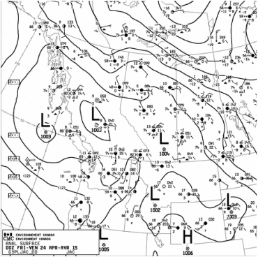
Picture00 UTC sounding for April 24 - upslope winds coming from the NE due to the low pressure system, partially over Alberta.
Steve, Paul and Melissa were our heroic forecasters for the day, providing us with all the details from the models. The RAP output suggested that there would be light precipitation for 0100 UTC and 0200 UTC, while the NAM  was predicting NE (upslope) winds from 0000 UTC to 0900 UTC.  Here at  Kananaskis the team decided to rotate throughout the night to check on the radar.  At 0700, during my turn to check I noticed what looked to be an upslope event, with precipitation coming from the NE moving SW towards KES.  Ida and I headed out to the site shortly after, to anticipate something interesting!  Upon arrival we checked the radar and we noticed that it had fizzled out on us - of course!  When we were convinced that nothing else would happen we headed back.   

Later that day Lucia was the first to arrive to the field at 1750 UTC.  What looked to be potential snow on the radar at 1830 UTC turned out to be nothing on site.  However it was snowing at Barrier Lake.  Ida and I decided to do a carsonde as that was looking to be our only chance to get snowflake pictures of the day.  We headed out to Fortress Mountain and arrived at 1830 UTC.  We made it to the top, without any transition or sign of snow, but something was brewing in the south, so we decided to wait for it to come our way.  At 1925 UTC we started seeing graupel with temperatures at 1.9 C, but with the wind it was hard to collect and the larger graupel would just bounce off the collection pad.  I did my best to shield the graupel from bouncing off, but I could only do so much.   We did manage to get photos still, though maybe not the best samples, due to the previously mentioned issues.  After some pictures and cold toes we left the base of Fortress Mountain at 2041 UTC, happy to have seen something!

Once we arrived at KES, we prepared a balloon launch.  We figured it would be best to launch during the storm and not stick to the usual schedule (00 UTC, 03 UTC, 06 UTC, 09 UTC, 12 UTC… etc), as the storm would be short lived.  We launched at 0015, with light snow at KES.  Pictures were not taken as the snow was melting too quickly with temperatures from 4.2 C to 6 C during the snowfall.   By 0040 UTC, there was no longer any snow at KES up until 0500 UTC when we left the site.  

Field Observers - Ida, Lucia & Juris

Field instrumentation - MRR, parsivel, geonor, datalogger, manual obs, carsonde (with micro snowflake photography) & one weather balloon launch

- Juris Almonte

0 Comments

April 22

4/25/2015

0 Comments

 
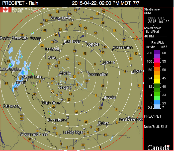
For this event, we were well prepared with forecasts being produced by students who had previously worked on the field project every 6 hours (00 UTC, 06 UTC, 12 UTC and 18 UTC).  Emilie P., was the forecaster at the time, tipping us off to expect precipitation around 18 UTC according to the 12 UTC  RAP and NAM run.  Environment Canada on the other hand did not have any precipitation predicted that afternoon.  The team here at Kananaskis diligently checked the radar and around 1800 UTC a line began forming around Banff that oriented NNE to SSW.   The line lingered there for a while.  Meanwhile, here at Barrier Lake there were strong warm winds, suggesting that it was drying out as it moved further West across the mountains, as nothing was appearing past that line on the radar.  However, at 2100 UTC something popped up to the West of KES so I headed off to KES to wait it out.  

An hour later at 2308 UTC very very light rain was observed over KES.  That line of rain lasted an hour, however only ten minutes of rain (moderate intensity) was actually observed.  The rest of the hour was mostly light rain to very very light rain.  Later in the evening at 0205 UTC about ten minutes of very small snow particles were observed, however temperatures were too warm to take photos.  

The site was all packed up by 0300 UTC, once the radar was clear.  During the event the temperatures dropped 10 degrees, starting at 15.5 C at 2200 UTC and cooling off to 5.5 C by 0240 UTC.  

Field observers: Ida & Juris
Instrumentation working/used: MRR, parsivel, geonor, time lapse camera, manual obs

Picture
Band of rain that seemed to be drying out as it moved West, with strong winds felt at Barrier Lake.
0 Comments

April 17-18, 2015 Storm Event

4/19/2015

0 Comments

 
According to the American models and the GEM regional, precipitation was expected to occur in the evening of the 17th. Around 1930 UTC the Strathmore, AB radar displayed convective precipitation brewing up southwest of Banff, AB and north of Lake Louise. As the system continued to grow larger, Juris, Melissa, Lucia, and I (Ida) rushed over to KES at 2130 UTC to prepare for this surprise event.
 
Upon arrival at KES, precipitation had not begun, though heavy cloud cover can be seen over Fortress Mountain. Our team quickly came up with a plan for Melissa and Lucia to do a car sonde at Fortress Mountain while Juris and I stayed behind at the KES site to take weather observations.

At KES, light drizzle began at 2210 UTC. Melissa and Lucia arrived at Fortress Mountain at 2213 UTC with rain already occurring at the base. At 2229 UTC, Melissa and Lucia drove through mixed precipitation where conditions remained the same up to the top of Fortress. At 2300 UTC, the mixed precipitation changed to snowfall though very few photos were taken as temperatures remained above 0˙C.

At 2350 UTC, blue skies appeared over KES and the radar no longer had precipitation coming our way. Our team decided to head back to the duplex to re-energize for the expected evening storm.

As the evening progressed, another system began to form. Juris and Lucia began the first shift at 0426 UTC. During the shift of our first team, precipitation began at 0510 UTC where rain and mixed precipitation was experienced. Two weather balloons were released (0600 UTC and 0900 UTC) though winds were missing for both.

Our second team (Melissa and I) arrived on site at around 0830 UTC to relieve our exhausted first team. During the shift of the second team, very light snow occurred throughout the night. Photos were difficult to capture as temperatures remained above 0˙C although aggregates and dendrites were seen. At 1050 UTC, photos were finally taken although problems with the flash arose. New batteries were placed into the flash however a few photos came out black as the flash (at times) continued to not respond. One weather balloon was released for 1200 UTC with… wait for it… WIND!! It is unclear how or why we achieved wind during this release as the same procedure was followed. Further investigation is needed on this issue.

At 1225 UTC, precipitation was no longer occurring at KES and the radar appeared clear of any system coming our way. Melissa and I (sleepily) packed and locked up the site and headed home to our beds. On the drive home, we enjoyed the beautiful eerie scenery leftover from the event. The view made the overnight shift worth the loss of sleep!

However, at 1500 UTC, Juris and Lucia rushed back to KES as another round of precipitation headed our way. Light snowfall was experienced though photos could not be taken as temperatures were above 0˙C. Large snowflakes and dendrites were noted. Precipitation ended at 1600 UTC.

Can you guess what happened next? Yes, another system headed our way again at around 2010 UTC! Juris and I arrived on site at 2045 UTC. We quickly set up a weather balloon launch for 2100 UTC. Unfortunately for this balloon launch, we did not receive wind. Snowfall began at around 2100 UTC with temperatures well above 0˙C (around 8˙C). Not long after, the sun came back out and the radar showed the system dissipating and moving northeast of KES.

For the most part, these events were undetected by the American models and the GEM regional however I am proud of the organization of the team and the way everyone jumped into action once we saw precipitation coming our way!


Field site participants – Juris, Melissa, Lucia, and Ida

Instruments working – MRR, Parsivel, Geonor, weather station, sounding system


- Ida Hung 

0 Comments

April 14, 2015 - Event of the Spring thus far

4/15/2015

0 Comments

 
Environment Canada issued a snowfall warning early evening of the 13th.  Our team, Melissa, Housseyni, Ida and myself checked the models to determine the start time for the event at KES.  The American models (RAP, NAM & GFS) suggested that precipitation would start anywhere from 0800 - 0900 UTC, whereas the GEM regional on the other hand had precipitation pegged to begin around 1500 UTC.  Since there was such a big discrepancy we decided to alternate checking the radar every 30 minute, starting at 0400 UTC, up until the event.  Throughout the night, all the precipitation was happening to the North/ North East of us.  

The GEM regional was not too far off, with very light precipitation starting around 1900 UTC. The drizzle did get heavier and did change into mixed precipitation, with a short transition into snow from 1900 to 2200 UTC. It cleared up for most of the afternoon, so two carsondes were conducted at Fortress Mountain.  Unfortunately, no precipitation was seen during the first carsonde, except for a few pieces of snowflakes here and there.  However the next carsonde that was conducted around 2200 UTC Melissa and Lucia noticed precipitation on the way up, but no transition line.  They were also able to take some pictures of snowflakes at the top of Fortress. I attempted to do a skisonde, but upon arrival at Nakiska Ski Resort at 21:30 UTC I had noticed snow at the bottom of the base, so Instead I turned back and conducted a carsonde from Nakiska ski resort to KES where a transition was observed from snow at the parking lot changed to mixed precipitation near hwy 40.  Snowflake pictures were taken throughout the day, however at the beginning snow was melting upon contact.  The bulk of the pictures were from the heavy snowfall, when large aggregates of snowfall was observed, sometimes around ~2 cm in diameter (see picture)

We ran into a few issues throughout the day. The roof of the fishing tent where snowflake pictures were being taken collapsed after one of the poles for the roof broke.  Problems arose with receiving wind information on the radiosondes. Winds throughout the event were very light, well under 5 m/s.  Balloons were launched every three hours until the end of the event, with one not working at 0300 UTC (April 15). During moderate to heavy snowfall, the MRR had to be constantly swept, as the dish collected snow quickly.  Luckily, this time we had no issues with icing on the dish.   
 
So far, this is the event of the season with all instruments running.  We finally received some moderate to heavy snowfall at KES, however accumulation topped up at about 5 cm, while accumulation at Barrier Lake was about 10 cm as seen on the duplex deck.  The event ended at 0400 UTC (2200 MDT) and left the site at around 0630 UTC after the final sounding of the day to capture the conditions at the end of the event. Radar indicated that the storm had moved to the South / South East of KES, with nothing else of concern, so we decided to call it a night.  Lastly, with the amount of snowfall we noticed that more animals were drawn to the open roads, including deer and a single moose, so driving home we were extra cautious.  

Field Participants - Melissa, Housseyni, Ida, Lucia and Juris
Instruments working - MRR, parsivel, GEONOR, sounding system (except winds), Datalogger & carsondes

- Juris Almonte
0 Comments

Waves of Snow

4/13/2015

0 Comments

 
We arrived on site at April 11 at 1300 UTC with the storms commencing around 1330 UTC.  This event was a bit of an odd case, as it was intermittent up until the following day.  Throughout the event, snowfall was anywhere from moderate to very very light, however it was predominantly very light snow or no snow at all. No rain was observed at the site during the entirety of the event. 

Snowflake photo taking was difficult as the temperatures at KES were above zero, however we did observe and note that at times particles were moderately to heavily rimed.  After our first wave, we noticed chinook like conditions at the site, with temperatures increasing and the air drying.  During a break in the storm, when photos could not be taken at KES, Ida, Dominic and Housseyni conducted a carsonde at Fortress Mountain.  They did not observe any snow-rain transition line on the way up, but were able to snowflake pictures at the top where snowfall was heavy.  The kestrel values were appropriate and not changing rapidly as we had witnessed a few days before.  This is perhaps due to the strong winds atop Fortress.

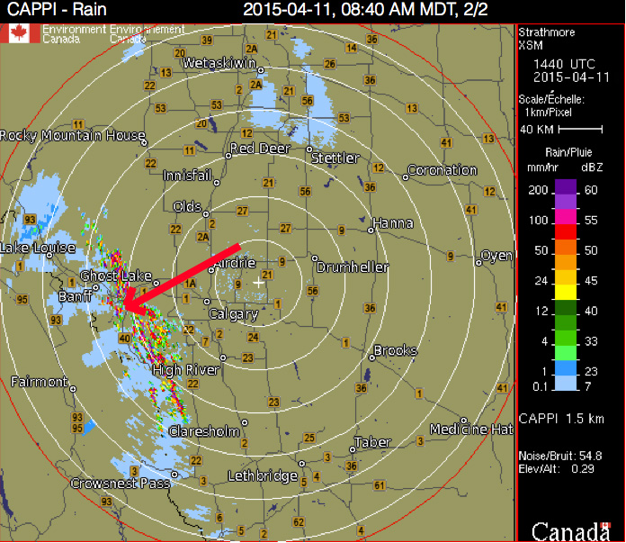
Majority of the storms that tracked in our direction came from the NW, popping up around Lake Louise and Banff before hitting KES.  What seemed to be a strong line of snowfall would either weaken or completely dissipate by the time it crossed the mountains from Banff to KES - donut hole effect.

The waves of precipitation continued on till the following day, ending in the afternoon, however snow was meek at best, usually only very very light snowfall, which the parsivel observed as no precipitation.   

Field site participants - Ida, Dominic, Melissa, Housseyni & Juris

Instruments working - MRR, parsivel, Geonor, weather station, sounding system

- Juris Almonte


Picture
Storms around us.
0 Comments

The Kananaskis Donut Hole

4/10/2015

0 Comments

 
There have been a few times now where we have noticed the "donut hole" over KES. This was coined by one of the emergency services members that had come to chat with our team at the beginning of the project. Oddly enough we would notice that it would be snowing at Barrier Lake, but on the drive towards KES we would cross a distinct line, where snow would stop, or in turn, become very light.   In fact, at times we could even see the skies clear up over top of us and the areas around us clouded over.  Though the picture does not do it justice, this is what we had observed.  This picture is from April 4th

- Juris Almonte


Picture
0 Comments

April 4, 2015 snow event

4/5/2015

0 Comments

 
Our group (Emilie P, Paul & Juris) was well prepared, forecasting the event the evening before.  After our conference call with the rest of the group we quickly prepared for a full day and night of observations, snowflake photography and weather balloon launching.  Environment Canada had a snowfall warning for Southern Alberta in effect. We arrived on site at 1620 UTC. Temperatures when we first arrived were around 1 C and rose to 3 C during the afternoon.  During this time snowflake photography was difficult as snow was melting upon contact on the collection pad. Later in the day when temperatures dropped, many dendritic snowflakes were observed, and at times particles were rimed.

Emilie P. and myself made the trip up to Fortress mountain to conduct a carsonde and take some snowflake pictures, where mainly aggregated dendritic snowflakes were observed.

Five weather balloons were launched during the event 18 UTC, 21 UTC, 00 UTC, 03 UTC and 06 UTC, respectively. Problems arose with the 00 UTC sounding as the computer had arbitrarily shutdown during the sounding.  Thankfully, Paul was able to retrieve the data up to around 200 hPa, prior to the shutdown.

We came across an issue with the MRR dish as we found some ice buildup at 0055 UTC, during one of our routine sweeps and was noted in the log book.  However, before leaving the site, we noticed that there was no longer ice on the dish.  The issue was brought up to the rest of the team and we have decided to use rubbing alcohol or anti-freeze solution if this were to occur again.  

Looking at the radar during the event, it appeared that the brunt of the storm hit southeast of KES around Lethbridge and further south. Although the event was not as big as we were expecting, with ~ 5 cm accumulation, the event was still successful, with all instruments running, good observations and pictures.  Just a few hiccups along the way, as is expected with field work!

We left KES at 0740 UTC after the radar returns were free of precipitation and looked to be dissipating in the vicinity. 

Paul, Emilie and Juris performed field duties during this event

- Juris Almonte


0 Comments

Snow storm forecasted for the Kananaskis Area

4/4/2015

0 Comments

 
A snowfall warning has been issued by Environment Canada for Kananaskis Nakiska Ridgetop where 10-20 cm of snow are expected in the area.  Precipitation should start at around 2100 UTC and end during the night. Émilie P., Paul and Juris are getting ready to go in the field. 

This may likely be The Storm of the project.  Stay tuned...

Have fun Juris, Émilie and Paul!

- Julie
0 Comments
<<Previous

    Archives

    April 2015
    March 2015

    Categories

    All

    RSS Feed

Powered by Create your own unique website with customizable templates.