Field activities began at approximately 0200 UTC on April 2 and concluded at 0600 UTC. A weather balloon was launched at approximately 0320 UTC. Light snow was observed shortly thereafter.
A few photos were taken from KES toward Mt. Kidd while light permitted. A few casual photos of snowflakes were also taken from snow on the ground and on the hood of the vehicle, but it was too dark to set up the tent and the lamp and light bulbs in the trailer were too faint to put everything together to take proper snow photos.
The Parsivel detected some larger snowflakes (> 5 mm). During a brief lull in snowfall, the Parsivel was shut down at approximately 0415 UTC, but was reconnected approximately 10 min later when the snowfall resumed.
The Micro Rain Radar detected reflectivity values > 10 dBZ above 1 km above the ground. However, there was a thin layer of snow (< 1 cm) that covered the dish and we were unable to sweep it off this time, so some MRR values may be inaccurate.
The snowfall intensity decreased to very light by approximately 0530 UTC, and we looked at the radar for the area and it showed that the system was weakening substantially. At 0600 UTC, we decided to head back to go to sleep.
When we were driving back, we noticed that snow accumulations along (and on) the highway were increasing, and heavier snowfall was occurring in line with Barrier Lake and the prevailing flow. The driving conditions were a bit treacherous for a few minutes, but we got back to our accommodations safe and sound.
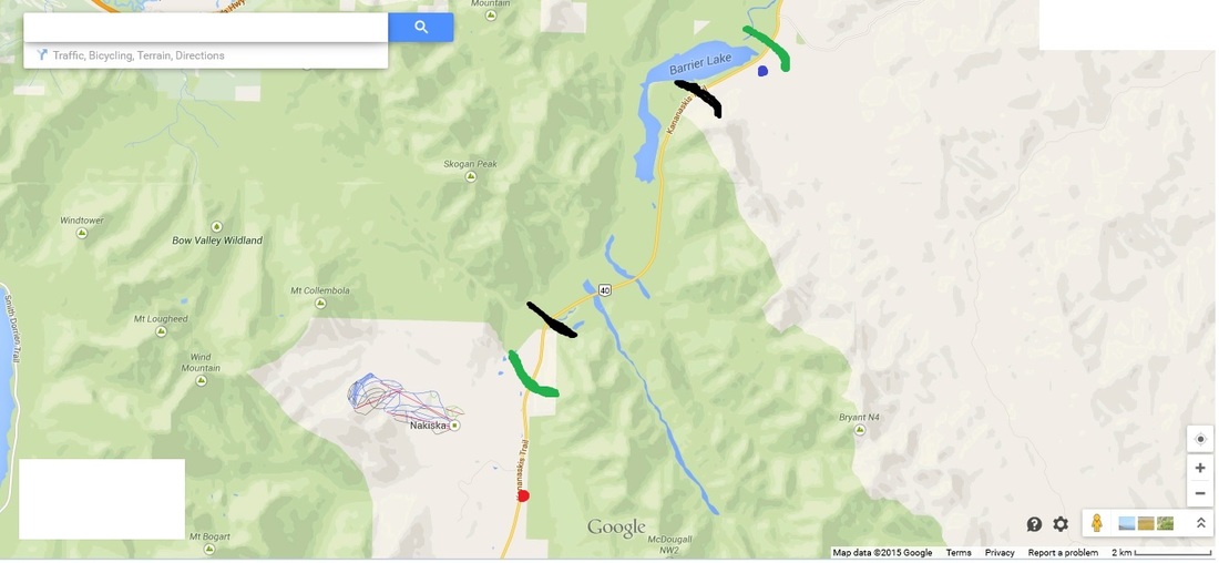
The map included shows precipitation accumulations along the highway. Within the green lines, precipitation accumulations were > 1 cm, and precipitation accumulations were 3-5 cm or more within the black lines. The red dot shows where KES is located and the blue dot shows where the Barrier Lake Field Station is situated.
Emilie P., Paul, and Stephen performed field duties during this event.
-Stephen Berg and Emilie P.
A few photos were taken from KES toward Mt. Kidd while light permitted. A few casual photos of snowflakes were also taken from snow on the ground and on the hood of the vehicle, but it was too dark to set up the tent and the lamp and light bulbs in the trailer were too faint to put everything together to take proper snow photos.
The Parsivel detected some larger snowflakes (> 5 mm). During a brief lull in snowfall, the Parsivel was shut down at approximately 0415 UTC, but was reconnected approximately 10 min later when the snowfall resumed.
The Micro Rain Radar detected reflectivity values > 10 dBZ above 1 km above the ground. However, there was a thin layer of snow (< 1 cm) that covered the dish and we were unable to sweep it off this time, so some MRR values may be inaccurate.
The snowfall intensity decreased to very light by approximately 0530 UTC, and we looked at the radar for the area and it showed that the system was weakening substantially. At 0600 UTC, we decided to head back to go to sleep.
When we were driving back, we noticed that snow accumulations along (and on) the highway were increasing, and heavier snowfall was occurring in line with Barrier Lake and the prevailing flow. The driving conditions were a bit treacherous for a few minutes, but we got back to our accommodations safe and sound.
The map included shows precipitation accumulations along the highway. Within the green lines, precipitation accumulations were > 1 cm, and precipitation accumulations were 3-5 cm or more within the black lines. The red dot shows where KES is located and the blue dot shows where the Barrier Lake Field Station is situated.
Emilie P., Paul, and Stephen performed field duties during this event.
-Stephen Berg and Emilie P.
 RSS Feed
